Length:
34 Miles
Surface:
Crushed
Gravel/
Primitive
The Virginia Creeper Trail
|
Length: Surface: |
The Virginia Creeper Trail |
|
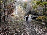
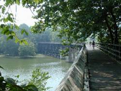
My wife and I rode the Creeper's western most 10 miles during the summer of 96 (we spent the night in Abington on our way to the Atlanta Olympics). The first few miles out of Abington has excellent surface conditions (crushed limestone). As we traveled east, the conditions slowly deteriorated. By the time we turned around (a bit past Alvarado), the surface was somewhat rocky, but still quite passable. Along the way, we crossed some incredible trestles, include a neat horseshoe trestle over the Holston River.
An unusual feature of the Creeper is that much of it crosses private farm land. This strange arrangement gives you the legal right of way through these area as long as you stay on the path. This also means that you must stop every few miles in order to open gates between property boundaries. You may also have to navigate around livestock, as my wife and I did when we found ourselves in the center of a cow herd. The Creeper Trail also has strong community support.
For example, on July 29, 2001 a rather large trestle over Whitetop Laurel creek was completely destroyed by
a local flood. A combination of volunteers, contractors, and the US Forest Service quickly pulled
together to clean up the mess and restore the trail. Within three weeks a temporary bridge was
in place! A permanent replacement is planned by Summer 2002.
|