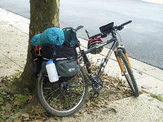
Aug 3 - All packed up for the rest of the trip |
Day 2: This morning, I loaded the "full package" (about 42 lbs) onto my bike, and started off early from my home in Montgomery Village, MD. My 10 mile ride out to the canal began along Route 124, which is not much fun during morning rush hour. However, traffic significantly eases up enough after passing under I-270 that I feel reasonable comfortable getting out in the road. At Darnestown, I pick up Route 28. This road has nice wide shoulders and I am heading against rush hour traffic, so it is pretty much smooth sailing from this point to the canal. After a few miles, I hang a left onto Seneca Rd. This is a narrow two lane road, but there is typically very little traffic along this section. After a few miles, I make the wild decent into the Seneca Creek valley and the final left turn onto Riley's Lock Road.
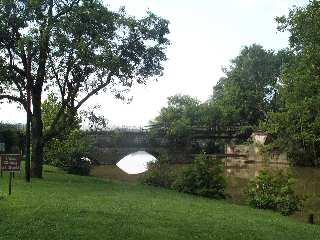
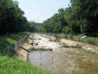
Mile 23 - Seneca Creek Aqueduct at Riley's Lock |
At this point, I pick up the towpath at Riley's Lock (Mile 22.8). Basically, I skipped ahead 3 miles by making a 20 mile detour. Again, this three mile section is part of my normal patrol area, so I had no regrets. However, I should point out that Blockhouse Point Cliffs (mile 21) is one of the more picturesque locations along the towpath.
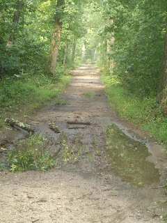
Large mud hole along lonely towpath |
Upstream from Riley's Lock and the Seneca Creek Aqueduct, the towpath becomes very remote. Occasionally, you will see groups of bird watchers along the next mile, but after that there will be very few folks. This section is often quite muddy, and that was definitely the case today. There were many mud holes along this section, and my legs were covered within a few miles. I was only able to average about 8 miles per hour along this section.
At mile 27.2, I decided to check out the access point to Mckee-Beshers Wildlife Area. This resulted in about a 3 mile detour out and back along a bumpy dirt road. There also appeared to be some abandoned towpath repair equipment at this location.
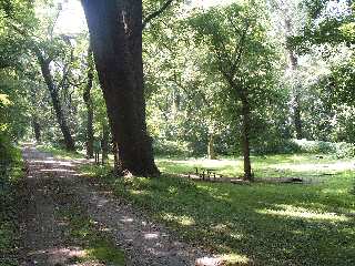
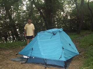
Mile 34.5 - Turtle Run Hiker/Biker Campsite |
After passing the Edwards Ferry Boat Ramp (mile 30.8), the towpath conditions significantly improved. I was able to increase my pace to about 12 miles per hour (pretty typical for me). You will find that the conditions will often change along the towpath. It depends on the surrounding soil (rock vs swamp) and which sections last received maintenance. You may find completely different conditions when you pass through. This was clearly the case up around mile 37. This area was a complete disaster during my July 2003 ride. After Hurricane Isabel ripped through this area in September 2003, the park service used that as an excuse to finally repair this section. Unfortunately, they used a very large ballast material which resulted in many complaints (although I had no problem with my tires). They have since repaired this section "correctly".
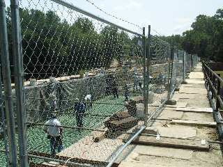
Mile 41.6 - Kayak Training Facility at Dickerson |
At mile 41.6 in the Dickerson Power Plant. The access gate was actually open, so I was able to get a couple of really good photos of the Kayak Training Facility located in the power plant's discharge spillway. This is occasionally used for US Olympic Team training. However, this was just a few weeks prior to the 2004 Olympics, so I figured the Team was probably training in Greece. A half mile upstream, work was busily proceeding on the Monocacy Aqueduct repairs. They had actually started removing parts of the 30 year old exo-skeleton support structure.
At Point-of-Rocks, MD (mile 42.8), the Park Service maintenance folks were finishing up the swivel bridge replacement (although the new bridge does not swivel). The lunch stop for today was also here at B & S Minimart, where I had a great Cold Cut Sub and reloaded on water. The temperate was well into the 90's by now, which actually caused my lame digital camera to overheat and stop working so I could not get a picture of the lunch stop or the railroad trains passing through town.
Mile 42.2 - Reconstruction work on the Monocacy Aqueduct. |
A few miles upstream, the sky quickly darkened and a very brief shower developed overhead. This very typical summer storm produced only very light rain at my location, but I suspect it was a full blown storm back toward my home (some 35 miles away). The storm did significantly cool down the afternoon, so much so that I was able to get my camera working again. By the time I reached Brunswick, the sky had turned azure blue. I made a quick sweep of the town looking for some water. However all the shopping centers are well out of town, so I decided to push on up towpath.
Mile 60.7 - The narrow pass at Harpers Ferry |
At mile 58, the 2160 mile long Appalachian Trail comes down off the Maryland mountains and follows the towpath for the next 2 miles. I stopped briefly here to speak to a hiker who was laying on the towpath reading a book. He was doing a short hike along the Maryland/Virginia section. This this area it is approximately the midpoint of the Appalachian Trail, so at this time a year you would not expect to meet many through hikers.
By 4:30 p.m. I had reached Harpers Ferry. My original plan was to overnight at the Huckleberry Hill campsite just a few miles up the river. However I still felt really good, so I decide to push on for the Antietam Campground. At Dargan Bend Recreation Area, I stopped to chat with a really nice group of college kids who were biking back to the Harpers Ferry Hostel after a day trip to Antietam. the previous day bike up from anglers inn, and it sounded as if they were often do some hiking at Gettysburg the next day. I soon reach the Antietam campsite, only to find that it was rather full with children. There were still a few hours a summit left so I decide to keep on going.
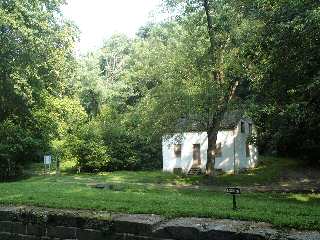
Mile 66.9 - The Lockhouse at Lock 37 |
A few days before leaving on my trip, I received an inquiry regarding the status of the route 34 bridge. Thus upon reached mile 72, I decided to climb the massive hill, and take a look at this major construction project. Basically, a brand new bridge is being built from scratch, right next to the old bridge. My assessment was that most people probably would not like to bike across this bridge until construction is completed. However, one bonus feature from the construction is that the tiny parking area, which was previously below the old bridge, has been replaced by a new paved parking area about a half-mile in downstream from the old location.
Daylight was now fading fast, so I pushed on to the Killiansburg Cave campsite. Upon arrival, I discovered the campsite was already occupied by Charlotte and Rick, a retired couple from Harrisburg, Pa.
Mile 73.5 - Ready to sleep at Killiansburg Cave campsite |