Display Driving Direction from:   North (via I-95)   South (via I-95)   East (via Rt 50)   West (via I-66)

The Clara Barton Parkway runs along the Maryland side of the Potomac River and is operated by the National Park Service. For anyone on the northwest side of DC, this is a very convenient location. It is quite easy to reach by car, and offers a relatively short bike ride to downtown.

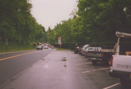
The parkway offers several small parking lots along it's length, but the most convenient lot is located right at the end of the parkway, where it intersects with Chain Bridge and Canal Rd. Once parked, you will bicycle into town on the unpaved C&O Towpath. Optionally, you can switch over to the paved Capital Crescent Trail after about one mile on the towpath.

A word of caution: On weekdays, the parkway is one-way inbound during mornings, and one-way outbound during evenings. Because of these changes, Google Maps will not offer routing directions on the changeable sections. Assuming you are coming from the Beltway, I recommend you ignore the Google computed directions and just remain on the parkway (unless directed otherwise by barricades). The best parking area is located just prior to the first stop light. If you see a stop light in the distance, pull off before you reach it.


1. Go toward Bridge: Leave the parking area by following the paved path toward the traffic lights. At the light, make a right onto Chain Bridge

2. Down to Towpath: Once on the bridge, cross over the canal and then take the access ramp down to the towpath

3. Right on Towpath: At the bottom of the ramp, turn right onto the Towpath. Continue for about 1 miles until you reach the footbridge over the canal at Fletcher's Boathouse.

4. Cross to paved trail: At the boathouse, cross over to the parallel Capital Crescent Trail (paved). Follow this for another mile until you reach Georgetown. Cross under the Key Bridge, and you will be on Water Street, underneath the Whitehurst Freeway.

5. Follow Waterfront: Continue on the trail along the waterfront. You will need to dismount and walk your bike when passing the outdoor cafes. After the cafes, pass the sundial and continue toward the boathouse.

6. Left at Boathouse: Make a left turn at the boathouse, crossing over a short bridge and entering a parking lot. Head toward the traffic light.

7. Right on Path: At the traffic light, make a right turn onto the bike path. Follow this path along the river until you reach the Lincoln Memorial Circle.

8. Follow Circle: Follow the circle counter-clockwise until you reach the closed off pedestrian area. From here, follow any of the bike paths along the National Mall.

Explore this route using: Google Maps or Google Earth

Bike Washington --> Vistor Guide --> Park and Bike Guide