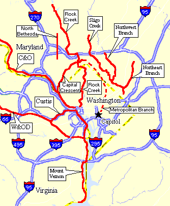
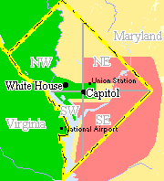
Descriptions of Major DC Area Trails
-
Length: 45 Miles - Width: 10 Feet - Surface: Paved
The W&OD (pronounced "wad") is probably the best all around trail in
the area. This is a 45 mile long rails-to-trails
conversion between Shirlington and Purcellville, VA. The surface is
paved for the entire length, and there is a side horse trail along much
of the route. Virginia has sunk a lot of investment into this trail, (and
continues to do so). The trail is continuously maintained and there are
several improvement projects ongoing.
The main complaints about this trail are its popularity (it can be
quite crowded at times), the number of street crossing in the eastern part,
and the fact that the trail follows a power line right-of-way for most
of its length. However, the western-most 15 miles are very nice, with a
mostly rural setting. Access to this trail from Roosevelt Island is made
by using the 4 mile long Custis Trail.
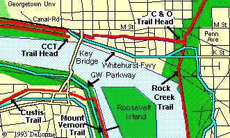
Detailed Map of Georgetown Area
|
-
Length: 4 Miles - Width: 10 Feet - Surface: Paved
The four mile long Custis Trail runs parallel to I-66 through Arlington,
VA, which is probably the most bike friendly jurisdiction in the region.
The Custis is mainly used as the easiest access route to the W&OD from
the downtown area. However, it also has numerous side trails that
provide easy access to many areas of Arlington. The trail is quite
narrow and has limited sight lines, however it is very well maintained
and has very few road crossing.
-
Length: 13 Miles - Width: 10 Feet - Surface: Paved/Crushed Stone
The CCT is another wonderful Rail-to-Trail
conversion, this route goes from K street in Georgetown to Downtown
Bethesda. The first three miles parallels the C&O Towpath, but then
heads up the hill through the affluent neighborhoods NW of DC. The first 7 Miles
between Georgetown and Bethesda are paved. Once you arrive in Bethesda, you can continue east using
the unpaved Georgetown Branch Trail to the Rock Creek Trail.
Access from the Roosevelt Island is also via Key Bridge. Again, head
for the C&O Towpath. Once you get there, hang a left and then look
for any access down the hill to your right toward Water
Street (there are several choices). At Water Street, hang a right. The CCT
starts where the street ends.
-
Length: 18 Miles - Width: 8 Feet - Surface: Paved
This is probably the most scenic of the trails. It runs south along the
Potomac River from Roosevelt Island
to George Washington's estate at Mount Vernon. Along the way, you will get a
great view of the aircraft at National
Airport and you will also pass through Olde
Town Alexandria. The trail is paved, but narrow. It is also typically
crowded on nice weekends. The route is mostly flat with a few hills at
the southern end. The trail is about 50% shaded and the river provides
a cooling breeze, so this is a nice route during the hot summer days.
-
Length: 184 Miles - Width: 12 Feet to Dual Track - Surface: Clay/Stone
This is my favorite trail in the area. The canal is mostly gone nowadays,
but its towpath remains. Now a National Historic Park, the C&O Towpath
follows the Potomac River for 184 miles between Georgetown and Cumberland,
MD. Along the way, sights will include Great Falls (mile 14), the Monocacy
River Aqueduct (mile 42), historic Harpers Ferry (mile 60), and the Paw Paw Tunnel
(mile 155). The canal bed still contains water up to about mile 22. From
then on, trees have pretty much taken over the remains of the old canal
bed. This makes the towpath very shady and cool during the hot summer months.
The trail surface is mostly finely crushed gravel and clay. Also, the thing
is almost completely flat (as long as you stay on the trail!).
Access to the canal from Roosevelt Island is via the Key Bridge. You
can get to Key Bridge by taking the funky looking pedestrian overpass at
the north end of the island parking lot. When you get to the far side of
the Key Bridge, cut through the park to your right, and that will take
you down to a footbridge which puts you right on the towpath. Beginning
at mile 26, you will find Overnight Camping Areas and water pumps about
every 5 miles. There are also modern accommodations available at Harpers
Ferry, WV (mile 160) and Hancock, MD (mile 124). For more information,
see the Towpath Biking Guide.
-
Length: about 20 Miles - Width: 8 Feet - Surface: Paved
This "trail" has slowly evolved over the years. It is really an informal
collection of paths that were eventually linked together to form this baby.
While the trail is not too bad in Montgomery County, it does leave something
to be desired in the District. In fact, a portion of the route is on-road
(Beach Drive). The good news is that this section of Beach Drive is mostly
closed to autos on the weekend. The remaining bike path sections in DC
are now in pretty poor shape. Sights on this route include the National
Zoo, and the Equestrian Center at the Candy Cane City playground. There
are also some nice picnic areas along the way and at the north end of the
path.
To get to the trail from Roosevelt Island, cross Key Bridge (as if
you are heading to the C&O Towpath). When you get to the footpath over
the Canal, don't cross it. Instead, follow the path to your right on the
M-street side of the canal. Eventually, the path becomes brick paved, and
then ends at the Rock Creek Path. Hang a left and good luck!.
-
Length: about 8 Miles - Width: 6 to 10 Feet - Surface: Paved
This is a nice "family trail" through the Sligo Creek Valley between Hyattsville
and Wheaton, Maryland. The trail is narrow in some spots and there
are a couple of busy intersection crossings. The south end of the
trail begins just west of the West Hyattsville Metro Station, where it
joins the Northwest Branch Trail. The north end terminates in Wheaton
Regional Park, near Wheaton Metro. The park makes a great place
for a family picnic.
-
Northwest Trail Length: 7 Miles - Width: 8 Feet - Surface: Paved
Northeast Trail Length: 4 Miles - Width: 8 Feet - Surface: Paved
These trails run along the two major branches of Anacostia River (Washington's
"other" river). Both trails begin near the eclectic community of Mount
Rainier. The Northwest Branch Trail heads up through Langley Park to Silver
Spring. The Northeast Branch Trail heads up toward Greenbelt.
Both trails provide easy access to the University of Maryland at College Park.
Like the Rock Creek Trail, these paths consist of several different
segments which have slowly evolved into a nice trail system. However,
the trails appear to be wider and in better condition than the Rock Creek
Trail. Future additions are also planned.
-
Length: 4 Miles, when complete - Width: 10 Feet - Surface: Paved
This new trail connects south Rockville to Bethesda.
The two major components (interstate overpasses) were finally completed in July 2003, however some sections
require riding on residential streets (until at least 2005). Regardless,
the trail provides a great commuter route to NIH and Downtown DC (by way of the Capital Crescent Trail).
Metropolitan Branch Trail: (proposed)
This trail will run north from DC's Union Station to Silver Spring, Maryland
along the west side of the CSX Railroad tracks. Combined with the Capital
Crescent Trail, it will eventually complete the "Bicycle Beltway" around
the Washington DC Business district.
|