These maps show the location of recreation trails in and around the Washington DC area. All these trails are suitable for bicycling. Most trails have a paved surface, however some use a "natural" surface. Click on trail names for more detailed information.
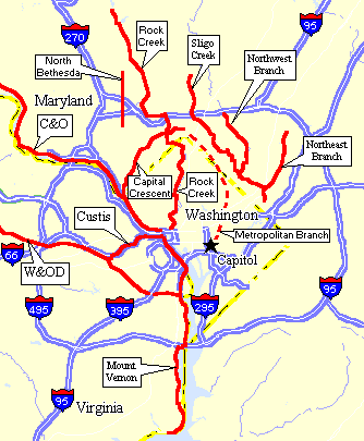
Map of DC Multi-Use Trails
|
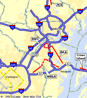
Trails in the Baltimore Washington Area
|
Wait! There are even more trails within a few hours drive of Washington. Click here for details.
Proposed Trail Projects
- WB&A Extension - Anne Arundel County
- Muddy Branch Trail - Montgomery County
- Matthew Hanson Trail - Montgomery County
- Mount Vernon Trail: 18 Miles - Paved
- Very scenic trail that runs along the Potomac River to George Washington's estate at Mount Vernon. Recommended ride for visitors.
- Washington & Old Dominion Trail: 45 Miles - Paved
- The W&OD (pronounced "wad") is probably the best all around trail in the area. This is a rail trail between Shirlington and Purcellville, VA.
- The Custis Trail: 4 Miles - Paved
- The Custis Trail runs parallel to I-66 through Arlington, VA. It connects the W&OD trail with downtown Washington DC.
- Capital Crescent Trail: 13 Miles - Paved/Crushed Stone
- The very popular CCT is another great rail trail project. The paved section runs from Georgetown to Downtown Bethesda. The remain section has a crushed limestone surface.
- Chesapeake & Ohio Towpath: 184 Miles - Natural Surface
- My favorite trail in the area, it runs from Washington DC all the way to Cumberland, MD. Watch for future extension to Pittsburgh, PA!
- Rock Creek Hiker/Biker Trail: about 20 Miles - Paved
(On Road Sections) - A loose collection of paths that were eventually linked together. Not too bad in Maryland, but the DC section does leave something to be desired. The DC on-road section is closed to traffic on weekends.
- Sligo Creek and Branch Trails: about 20 Miles - Paved
- Maryland's Anacostia Tributary Trails start near Mt Rainier, and provides connections to Wheaton, College Park, and Greenbelt.
- North Bethesda Trail: 4 Miles - Paved
(On Road Sections) - This trail provides an excellent commuter connection between Rockville and Bethesda.
- Metropolitan Branch Trail: (proposed)
- This trail will run north from DC's Union Station to Silver Spring, Maryland along the west side of the CSX Railroad tracks.
- Baltimore, & Annapolis Trail: 13 Miles - Paved
- Nice trail between Annapolis and Glen Burnie. Connects to the BWI Trail. Recommended ride for beginners.
- BWI Trail: 11 Miles - Paved
- Cool loop trail around Baltimore-Washington International Airport.
- Washington, Baltimore, & Annapolis Trail: 22 Miles, when complete - Paved
- Will provide crucial link between Washington and Anne Arundel Count.
- Cross Island Trail: 5 Miles - Paved
- New trail running across Kent Island. Nice stop for when heading to the beach. Recommended ride for beginners.
- Northern Central Rail Trail: 41 Miles - Crushed Limestone
- Excellent rural trail running from Ashland, MD to downtown York, PA.