Bike Washington’s
C&O Canal Bicycling Guide
Mile 70 thru 82
| Trip Planning | Mile-by-Mile | Trip Reports | Info-to-Go |
|
|
Bike Washington’sC&O Canal Bicycling Guide | Mile 70 thru 82 |
|
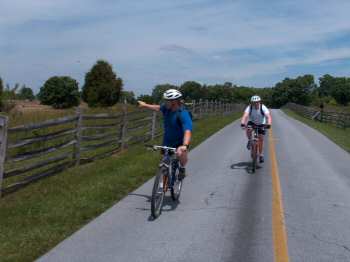
Mile 76.6 - Side trip to the Antietam National Battlefield
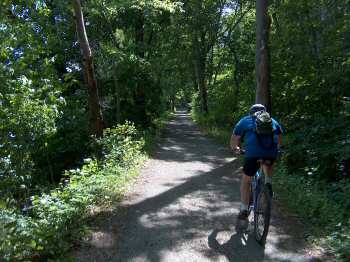
Mile 74 - On the towpath
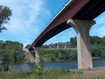
Mile 72.8 - Route 34 bridge to Shepherdstown, WV
This section, noted by its big curves, is located near the Antietam National Battlefield. Antietam was the site of the Civil War's bloodiest battle. The auto tour route through the battlefield also provides an excellent side trip for cyclists.
At mile 72.8, the towpath crosses under the Route 34 bridge. You can use this crossing to reach Shepherdstown, West Virginia which is located just across the river. (NOTE - June 2006: Bridge undergoing complete reconstruction, but nearly complete!) While on the bridge, you can't help to notice the charming Bavarian Inn, which sits on a cliff overlooking the river (Expensive, but recommended!). This town is the home of Shepherd University, and thus has several restaurant and lodging options. One popular restaurant is The Old Pharmacy Cafe & Soda Fountain, located at the bottom of E. German Street. In January 2000, the town was briefly in the international spotlight when it hosted the Israeli-Syrian negotiations.
A side trip to the Antietam National Battlefield is recommended. I think the easiest way to reach town is by using Snyder's Landing Road (Milepost 76.6). Bowie Rd to Mondell Rd (at Taylor's Landing - Milepost 81) also works well, but it can be tricky finding the correct turns (note the railroad on the map - use that to help keep your bearings). Whichever route you choose, expect to climb some pretty good hills!
Other than the big curves, there is not very much of interest along the towpath. The Killiansburg Cave, located about 50 feet above the towpath at mile 75.7, provided shelter to the town folks during the Antietam Battle. The foliage is fairly heavy in this section which makes it seem quite remote, however it also makes this section quite cool in the summer. Despite the remote feel, access points are fairly common.
Access Points: The easiest way to reach the Sharpsburg area from Washington:
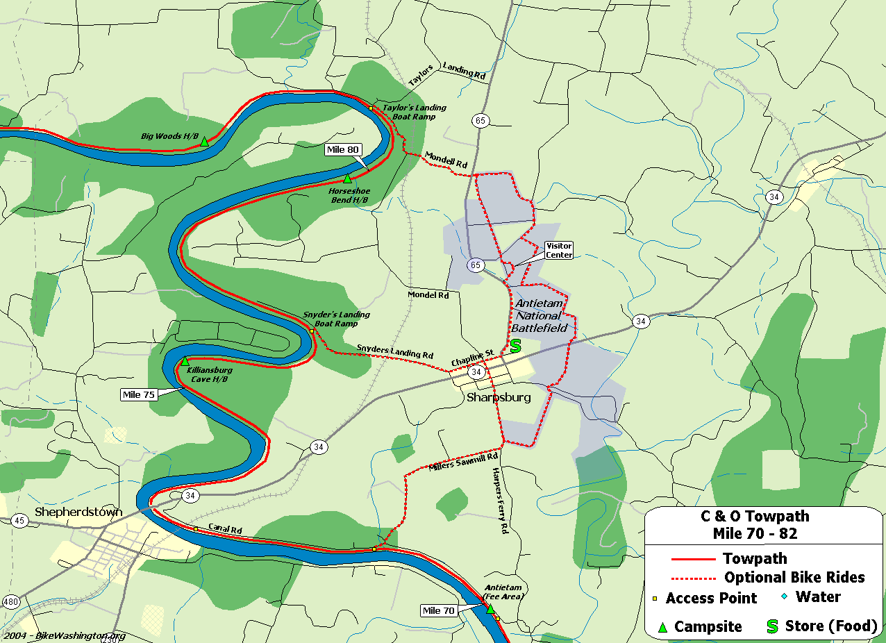
Towpath Map - Mile 70 thru 82
| Mile | Name | Info | |||||
|---|---|---|---|---|---|---|---|
| 69.3 | Antietam Aqueduct | The forth of 11 stone aqueducts constructed. Crosses Antietam Creek, which flows through the famous battlefield. | |||||
| 69.8 | Antietam Creek Recreation Area | Easy vehicle access - 20 Campsites - Fee Area: $10/Night | X | X | X | ||
| 71.5 | Pack Horse Ford | Conferderate Army crossed here after the Battle of Antietam | |||||
| 72.8 | Route 34 Bridge | Large Parking Area, about 0.1 mile downriver from bridge. Restaurants located across river in Shepherstown, about 3/4 mile. | X | X | |||
| 72.8 | Bavarian Inn (map) | 304.876.2551: Directly across river via Route 34 Bridge. Probably one of the nicest places to stay along the towpath. | X | ||||
| 72.8 | Thomas Shepherd Inn (map) | 888.889.8952: Cross Route 34 Bridge. About 1/2 Mile past Bavarian Inn | X | ||||
| 72.8 | Clarion Hotel (map) | 304.876.7000: On the far side of town, past the Thomas Shepherd Inn. | X | ||||
| 72.8 | Comfort Inn (map) | 304.876.3160: Cross Route 34 Bridge. Right onto Route 45. Located on right at 2001 Maddex Square Drive. | X | ||||
| 72.8 | Shepherdstown Dining (map) | Numerous dining options in this university town, including pizza, Chinese, and Thai. Cross bridge and ride up the hill. Left at 4-Way stop onto W German Street. | X | ||||
| 72.8 | Blue Moon Cafe (map) | 304.876.1920: Popular pub just one block off the beaten path. Corner of Princess & High Streets. | X | ||||
| 72.8 | Shepherdstown Pedal and Paddle (map) | 304.876.3000: Full service bicycle repair shop, including bicycle parts and rentals. Open most days by noon. 115 W. German Street | |||||
| 75.3 | Killiansburg Cave H/B | Hiker/Biker campsite. 1.3 miles from vehicle access at mile 76.6 | X | X | |||
| 75.7 | Killiansburg Cave | Large Cave about 20 above path in cliffs. (Hard to see through summer foliage) | |||||
| 76.8 | Snyders Landing Boat Ramp | Easiest access to Sharpsburg and Antietam Battlefield | X | ||||
| 76.8 | Jacob Rohrbach Inn (map) | 301.432.5079: A Bed and Breakfast in Sharpsburg, MD - About 1 mile from trail, near Antietam Battlefield. 138 W. Main St. | X | ||||
| 76.8 | Barron's Canal Museum (map) | A long time fixture on the canal, now owned by the Tyler Family. Open on weekends only. | |||||
| 76.8 | Antietam Guest House (map) | 301.992.9767: Quiet location in Sharpsburg, just one block off Main Street. Locked bike store. Great food nearby | X | ||||
| 76.8 | Battleview Market (map) | 301.432.2676: A bit off the trail, but the deli here is a great food option when visiting the Antietam Battlefield. 5331 Sharpsburg Pike. | X | ||||
| 76.8 | Captain Benders Travern (map) | 301.432.5813: Great food, micro-brew beers, wine and mixed drinks. Easy trek from Snyder's Landing into town. Not far from Antietam Battlefield. 113 East Main Street | X | ||||
| 76.8 | Antietam National Battlefield (map) | 301.432.5124: Location of the bloodiest one-day battle in US history. On Sept 17, 1862, nearly 23,000 solders were killed at this location. The auto tour route also makes a nice bicycle tour. | |||||
| 79.9 | Horseshoe Bend H/B | Hiker/Biker campsite. 1.1 miles from vehicle access at mile 81.0 | X | X | |||
| 80.9 | Taylors Landing Boat Ramp | Access to Antietam Battlefield | X | ||||
| 82.5 | Big Woods H/B | Hiker/Biker campsite. 1.5 miles from vehicle access at mile 81.0 | X | X |