Bike Washington’s
C&O Canal Bicycling Guide
Camping
| Trip Planning | Mile-by-Mile | Trip Reports | Info-to-Go |
|
|
Bike Washington’sC&O Canal Bicycling Guide | Camping |
|
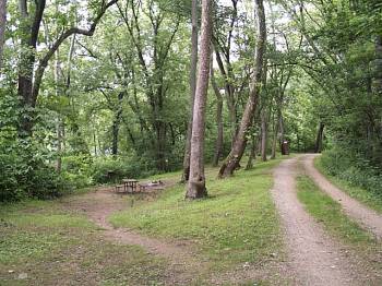
Killiansburg Cave (75.2) is a very typical Hiker/Biker campsite.
Most other sites are located a bit farther from towpath.
Where can I camp along the towpath? There are plenty of camping options along the towpath. Rustic "Hiker/Biker" Campsites (H/B) are provided about every 5 miles beginning at Mile 16. Each camp site has a water pump, Jiffy John, grill, and picnic table. Officially, these sites are "First Come, First Serve" and only one group is permitted at each site (up to eight persons). However, in practical terms it is often necessary to share campsites as I did in 2004. This is a great way to meet other travellers and share experiences.
If you prefer a few more amenities (like pool, showers), then you can choose some of the nice private campgrounds located near the path.
When choosing H/B campsites, you should consider the distance to the nearest "access point". Some may want easy access (for equipment "drops"), while others may want a remote location for "peace and quiet". Also some sites are located next to a railroad or interstate, so don't expect a good night sleep at these locations.
Fires are restricted to fire rings and grills in all H/B campsites. Portable off-ground grills are also permitted, but coals must be removed from the park after use. Dead wood may be collected solely for use in campsite fires. Wood can not be removed from the park.
Note: Fees are required at Drive-In campsites. Fees are charged on a per site/night basis, and apply even if you do not drive in. All other hiker biker sites are free.
For More Information: Refer to the National Park Service Web Site.
| Mile | Name | Info |
|---|---|---|
| 11.5 | Marsden Tract Campground (map) | 301.299.3613: PERMIT REQUIRED - reserved for civic/scout organizations only. $20/night. Call for permit. |
| 16.6 | Swain's Lock #21 | Five Campsites - nearby vehicle access. Newly restored lockhouse is now available for lodging with full amenities. |
| 26.0 | Horsepen Branch H/B | Hiker/Biker campsite. 1.2 miles from vehicle access at mile 27.2. |
| 30.5 | Chisel Branch H/B | Hiker/Biker campsite. 0.3 miles from vehicle access at mile 30.8 |
| 34.5 | Turtle Run H/B | Hiker/Biker campsite. 1.0 miles from vehicle access at mile 35.5 |
| 38.2 | Marble Quarry H/B | Hiker/Biker Campsite. 1.4 miles from vehicle access at mile 39.6 |
| 42.4 | Indian Flats H/B | Hiker/Biker campsite. 0.3 miles from vehicle access at mile 42.1 |
| 47.6 | Calico Rocks H/B | Hiker/Biker campsite. 0.8 miles from vehicle access at mile 48.2. Located near a busy railroad line, so earplugs are suggested. |
| 50.3 | Bald Eagle Island H/B | Hiker/Biker campsite. 0.5 miles from vehicle access at mile 50.8. Located near a busy railroad line, so earplugs are suggested. |
| 54.0 | Brunswick Family Campground (map) | 301.834.9950: Private Campground - Showers. Located between towpath and river. Appears to be VERY popular with RVs, but expect railroad noise. Cabin and Bicycle Rentals also available. |
| 62.9 | Huckleberry Hill H/B | Hiker/Biker campsite. Remote - No nearby vehicle access. |
| 69.8 | Antietam Creek Recreation Area | Easy vehicle access - 20 Campsites - Fee Area: $10/Night |
| 75.3 | Killiansburg Cave H/B | Hiker/Biker campsite. 1.3 miles from vehicle access at mile 76.6 |
| 79.9 | Horseshoe Bend H/B | Hiker/Biker campsite. 1.1 miles from vehicle access at mile 81.0 |
| 82.5 | Big Woods H/B | Hiker/Biker campsite. 1.5 miles from vehicle access at mile 81.0 |
| 90.9 | Opequon Junction H/B (map) | Hiker/Biker campsite. Remote - No nearby vehicle access. |
| 95.2 | Cumberland Valley H/B (map) | Hiker/Biker campsite. Remote - No nearby vehicle access. |
| 99.4 | Jellystone Park (map) | 301.223.7117: Private Campground - Full Service RV and Cabins. Located 2 Miles south of Williamsport along Route 68. Showers, pool, camp store. |
| 99.4 | Hagerstown KOA (map) | 301.223.7571 : Private Campground - Full Service RV and Cabins. Located 3 Miles north of Williamsport along Kemp Mill Rd. Showers, pool, camp store. |
| 101.2 | Jordan Junction H/B (map) | Hiker/Biker campsite. 1.9 miles from vehicle access at mile 99.3 |
| 109.6 | North Mountain H/B (map) | Hiker/Biker campsite. 0.4 miles from vehicle access at mile 110.0 |
| 110.0 | McCoys Ferry Recreation Area (map) | Primitive RV and Tent Camping - Fee Area $10/night |
| 112.1 | Fort Frederick State Park (map) | ?301.842.2155: Massive pre-revolutionary fort. Easy access from towpath. Water is available from hydrant, just 20 feet past the railroad crossing on the left. |
| 116.0 | Licking Creek H/B | Hiker/Biker campsite. 1.5 miles from vehicle access at mile 114.5. Located Near I-70 - Subject to traffic noise. Earplugs suggested for camping. |
| 120.4 | Little Pool H/B (map) | Remote Hiker/Biker campsite - No vehicle access. Located Near I-70 - Subject to traffic noise. Earplugs suggested for camping. |
| 126.4 | White Rock H/B (map) | Hiker/Biker campsite. 1.2 miles from vehicle access at mile 125.2 |
| 129.8 | Leopards Mill H/B (map) | Hiker/Biker campsite. 0.9 miles from vehicle access at mile 130.7 |
| 130.0 | Happy Hills Campground (map) | 301.678.7760: Private Campground - Full Service RV and Tent Camping (200 Sites). Cabins and Horse Stables available. 12617 Seavolt Rd |
| 133.6 | Cacapon Junction H/B (map) | Remote Hiker/Biker campsite - No vehicle access. |
| 139.2 | Indigo Neck H/B (map) | Hiker/Biker campsite. 1.6 miles from vehicle access at mile 140.8 |
| 140.8 | Fifteen Mile Creek Recreation Area (map) | Fee Area: $10 to $20. A Drive-in site with RV and tent sites (Primitive Facilities - No RV Hookups). Free parking available alongside railroad embankment. |
| 140.8 | Little Orleans Campground (map) | 301.478-2325: Private Campground - RV and tent sites 1/4 mile from the towpath. Showers, pool, camp store. |
| 144.5 | Devil's Alley H/B (map) | Remote Hiker/Biker campsite. No vehicle access. |
| 149.4 | Stickpile Hill H/B (map) | Remote Hiker/Biker campsite. Rough access point 0.6 miles away at Mile 150 |
| 151.1 | Three Otters Eco Retreat (map) | 304.947-5446: Some really unique lodging options are available, just across the river from the towpath. They also offer convenient canoe ferry service. |
| 154.1 | Sorrel Ridge H/B (map) | Remote Hiker/Biker campsite - Rough access point 0.7 miles away at Mile 153.4 |
| 156.2 | Paw Paw Tunnel Campground (map) | Easy vehicle access - Tent Campsites - Fee Area: $10/Night |
| 156.9 | Purslane Run H/B (map) | 0.7 miles from vehicle access at mile 156.2 |
| 162.1 | Town Creek H/B (map) | Hiker/Biker campsite. 0.2 miles from vehicle access at mile 161.9 |
| 164.8 | Potomac Forks H/B | Remote Hiker/Biker Campsite - No vehicle access. |
| 166.7 | Camp Potomac (map) | 301-729-1300: Private camping facility 1.5 mile from the canal. Open to scouts and other youth groups. Two cabins and eight campsites available. Email bsapotom@gmail.com for reservations. |
| 169.2 | Pigmans Ferry H/B (map) | Remote Hiker/Biker campsite - No vehicle access. |
| 173.3 | Spring Gap Recreation Area (map) | Primitive RV and Tent Camping - Fee Area $10/night. Store located on Route 51. |
| 175.4 | Iron Mountain H/B (map) | Hiker/Biker campsite. Access from nearby Route 51. Located near active railroad trestle. Earplugs suggested for camping. |
| 180.0 | Evitts Creek H/B (map) | Hiker/Biker campsite. 0.7 miles from vehicle access at mile 180.7 |
| 184.5 | Cumberland YMCA (map) | 301.777.9622 : For about $12, you can pitch your tent across the street from the Y. Includes use of indoor showers and restrooms. See PROGRAMS on website for more details. About 1 mile from the trail. 601 Kelly Road, Cumberland, MD |