Bike Washington’s
C&O Canal Bicycling Guide
Parking and Access Points
| Trip Planning | Mile-by-Mile | Trip Reports | Info-to-Go |
|
|
Bike Washington’sC&O Canal Bicycling Guide | Parking and Access Points |
|
Where can I leave my car? While enjoying your overnight trip down the towpath, the last thing you want to worry about is your car. This section provides some tips about where to leave your car so you don't need to worry.
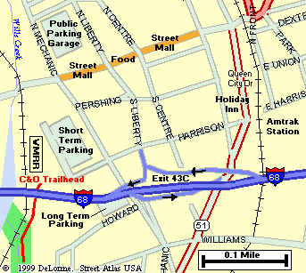
Map of Cumberland Trailhead |
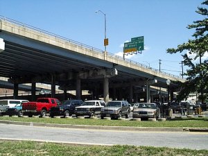
Cumberland, MD: In Summer 2001, a new long term parking lot was established near the Cumberland Trailhead. This lot is located under I-68. The first time I saw the lot, I was immediately concerned. The lot is fairly isolated and has no visibility from the Visitor Center. After the first year, it seems the word is "so far, so good". There has so far been no reported break-ins or vandalism.
If this fact does not reassure you, then an alternative parking suggestion would be the public parking garage located two blocks north of the visitor center, at the corner of N Mechanic and Frederick Streets. Unlike the long-term lot, the parking garage will cost you some money ($4 per day). When I asked the parking attendant if they had any "crime problems" with overnight parking, he said no. He then directed my attention to the other side of the street. The main police station is located right across from the garage!
Long-Term Cumberland Lot |
Great Falls, MD: Many people like to leave their cars at the Great Falls Visitor Center, which is located 14 miles outside Washington. The lot is very easy to get to from the Capital Beltway (Exit 41), and it's out in boonies. The problem with this lot is that it's 14 miles outside of Washington! If you're going to do the towpath, you've got to do the whole thing! <grin> Besides, downtown Washington is a great city to see by bicycle.
Now, I perfectly understand if some folks are freaked out by the thought of driving in a "big" city like Washington (it's really not that bad). If this is the case, then your best bet would be Great Falls. Just be sure to check in at the Visitor Center to let them know you are leaving your car overnight.
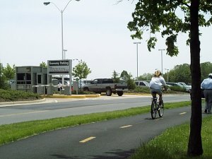
Mount Vernon trail passes Reagan National Airport parking lot. |
Washington, DC: If you leave you car at the Georgetown end, then your best bet would be to use one of the many underground parking garages. There is one on just about every block. However, this option will a bit pricey. The garage at the corner of M and Water St was charging $14 per day (I expect the rates vary).
An alternative to the downtown parking garages is the long-term parking lot at Reagan National Airport. This lot only charges about $9 per day, and is easily reached from the George Washington Memorial Parkway and I-395. This lot is located about five miles south of the Georgetown Trail Head, but it is a really wonderful bike ride along the Potomac River using the Rock Creek and Mount Vernon Trails. This map will help show you the way.
The following table lists all "reasonable" access points along the towpath. Most of these locations have some parking accommodations. Generally speaking, overnight parking is discouraged at most of these access points. However, if you would like to leave your vehicle overnight, I suggest you contact the nearest Visitor Center. This lets the park rangers know which vehicles are legitimately parked.
| Mile | Name | Info |
|---|---|---|
| 0.3 | Start of Towpath | Just south of the Pennsylvania Ave and Rock Creek Pkwy intersection. Continue downstream via the Rock Creek Bicycle Trail. |
| 0.5 | Georgetown Visitor Center | 202.653.5190: National Park Visitor Center. Canal boat rides available. 1057 Thomas Jefferson St, NW, Washington, DC 20007 |
| 1.6 | Georgetown University (map) | Access via tunnel underneath the Canal. Near intersection of Canal and Foxhall Roads. |
| 3.1 | Fletcher's Cove | 202.244.0461: Snack Bar. Single-speed bike and boat rentals. Nice area for a picnic. Parking available. |
| 4.0 | Chain Bridge (map) | Last bicycle river crossing to Virginia until Milepost 34.5 |
| 5.0 | Lock #5 | Modern footbridge over parkway to Ridge Drive near the corner 61st Street. |
| 5.4 | Lock #6 | Parking area along Clara Barton Parkway |
| 7.0 | Lock #7 | Parking area along Clara Barton Parkway |
| 8.4 | Cabin John (map) | Cabin John Shopping Center (at MaCarthur and 79th St) located about 0.5 mile away from river (Deli / Store). Cross lock and follow wide path to left. Becomes paved Riverside Ave. Follow thru tunnel and continue 79th St. |
| 8.8 | Lock #10 | Parking area along Clara Barton Parkway |
| 10.8 | Carderock Recreational Area (map) | Picnic, rest rooms, water. Very easy access from I-495. |
| 11.5 | Footbridge | Water on opposite side of canal. Access to MaCarthur, 0.1 mile west of Brickyard Rd. Loading only - No Parking. |
| 12.4 | Old Angler's Inn (map) | Popular free parking area across from Old Angler's Inn on MaCarthur Blvd. VERY Crowded. Access to optional Berma Rd route. |
| 14.3 | Great Falls Tavern Visitor Center | 301.767.3714: National Park Visitor Center. Operational Lock #20 located here. Paid parking available. 11710 MacArthur Blvd, Potomac, MD 20854 |
| 16.6 | Swain's Lock #21 | Five Campsites - nearby vehicle access. Newly restored lockhouse is now available for lodging with full amenities. |
| 19.7 | Pennyfield Lock #22 | Parking Lot - Access to River Road at Esworthy Rd |
| 22.1 | Violettes Lock #23 | This lock also marks the end of the watered canal basin. With a few exceptions, the canal basin is mostly abandoned upstream from this location. |
| 22.8 | Rileys Lock #24 | Parking and access to River Road. |
| 27.2 | Mckee-Beshers Wildlife Area | Remote access via Sycamore Landing Rd, 0.75 miles from River Rd. Public hunting area. In July, check out the Sunflower fields during peak bloom. |
| 30.8 | Edward Ferry Boat Ramp | Access to Poolesville, MD |
| 35.7 | Whites Ferry (map) | 301-349-5200: NOTE: As of Dec 28, 2020, the Ferry is CLOSED due to a legal dispute. No current access to Leesburg and no estimate if/when it may resume operation. |
| 39.5 | Dickerson Conservation Park (map) | Access from Martinsburg Rd. |
| 42.1 | Monocacy Aqueduct | This impressive structure is the largest aqueduct on the towpath. Originally completed in 1833, was restored in 2005. |
| 44.6 | Nolands Ferry | Boat Ramp and Picnic Area. Access from New Design Road. |
| 48.2 | Point of Rocks, MD | This town marks the location where the Potomac river cuts through the Catoctin Mountain ridge. The Route 15 Bridge provides alternate bike access to Virginia (when Whites Ferry is closed). Note that Route 15 is very hazardous and NOT recommended for bicycle access to Leesburg. Use state route 665 instead. |
| 50.9 | Lock 29 | Access from Lander Road |
| 55.0 | Brunswick, MD | Ample parking. A couple of restaurants, but no easily accessible convenience stores. Access to Virginia via route 17/287 |
| 58.0 | Appalachian Trail | The famous 2,181 mile long hiking trail that runs from Maine to Georgia. The trail comes down off South Mountain, and follows the towpath upstream for about 3 miles, leaving at Harpers Ferry. |
| 60.7 | Harpers Ferry, WV (map) | National Historic Park. Railroad Station, serving Amtrak and MARC (No bicycles on MARC). IMPORTANT: The footbridge to Harpers Ferry was destroyed by a train derailment in Dec 2019. It is closed until further notice. |
| 61.2 | Maryland Heights Hiking Trail (map) | Use footbridge over canal - Hiking trail to top of cliffs overlooking Harpers Ferry |
| 61.5 | Harpers Ferry Road Access | Very small parking lot. No parking on weekends (raft access only) |
| 64.9 | Dargan Bend Recreation Area | Large Parking Area (40-50 vehicles) - Access from Back Rd |
| 67.4 | Mountain Lock Recreation Area | Parking Area (10-15 vehicles) - Access from Limekiln Rd, just down hill from Harpers Ferry Rd |
| 69.8 | Antietam Creek Recreation Area | Easy vehicle access - 20 Campsites - Fee Area: $10/Night |
| 72.8 | Route 34 Bridge | Large Parking Area, about 0.1 mile downriver from bridge. Restaurants located across river in Shepherstown, about 3/4 mile. |
| 76.8 | Snyders Landing Boat Ramp | Easiest access to Sharpsburg and Antietam Battlefield |
| 80.9 | Taylors Landing Boat Ramp | Access to Antietam Battlefield |
| 84.2 | Dam #4 | |
| 93.8 | Potomac Fish and Game Club | 301-223-9871: Private club. Public access may be restricted. |
| 99.4 | Williamsport Visitor Center | 301.582.0813: National Park Service Visitor Center. Great displays inside the Cushwa building. A Bike Repair Station is also available at this location. |
| 106.6 | Feeder Dam #5 | Access via Dam #5 Road - Parking Area. |
| 108.6 | Four Locks | Large parking area, boat ramp. |
| 110.0 | McCoys Ferry Recreation Area (map) | Primitive RV and Tent Camping - Fee Area $10/night |
| 112.1 | Fort Frederick State Park (map) | ?301.842.2155: Massive pre-revolutionary fort. Easy access from towpath. Water is available from hydrant, just 20 feet past the railroad crossing on the left. |
| 114.5 | Western Maryland Rail Trail (map) | Eastern Access Point. Trailhead located 0.7 miles downstream of this point at Route 56 |
| 124.1 | Hancock, MD | Several Stores and Restaurants. Very easy access from towpath |
| 130.7 | Cohill, MD | Access from Route 144 via Willow Road |
| 140.8 | Fifteen Mile Creek Recreation Area (map) | Fee Area: $10 to $20. A Drive-in site with RV and tent sites (Primitive Facilities - No RV Hookups). Free parking available alongside railroad embankment. |
| 150.0 | Bonds Landing | Rustic access point from Kasecamp Road. Four wheel drive may be required. |
| 153.4 | Gross Hollow | Very rustic access point from Sportsman Club Rd - Four wheel drive only |
| 156.2 | Paw Paw, WV (map) | General Store and Quick Mart. Located about 1 mile from towpath, across the river, via Route 51. |
| 161.9 | Town Creek, MD | Access point to Route 51 located 0.2 miles upstream from lock #67 |
| 166.7 | Oldtown, MD | Toll bridge over to Green Spring, WV |
| 170.8 | Buckley Rd | Probably access point from Route 51 |
| 173.3 | Spring Gap Recreation Area (map) | Primitive RV and Tent Camping - Fee Area $10/night. Store located on Route 51. |
| 175.4 | Iron Mountain H/B (map) | Hiker/Biker campsite. Access from nearby Route 51. Located near active railroad trestle. Earplugs suggested for camping. |
| 180.7 | Evitts Creek Aqueduct | Access from nearby Route 51 |
| 184.5 | Cumberland, MD (map) | Trail heads for both the C&O and GAP trails. Several restaurants nearby; Continue north past the historic railroad station, then turn right at Baltimore St. |