Bike Washington’s
C&O Canal Bicycling Guide
Mile 50 thru 70
| Trip Planning | Mile-by-Mile | Trip Reports | Info-to-Go |
|
|
Bike Washington’sC&O Canal Bicycling Guide | Mile 50 thru 70 |
|
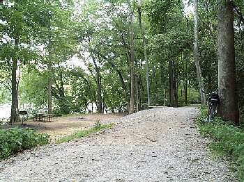
Mile 62.9 - The Huckleberry Hill Hiker/Biker campsite
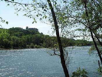
Mile 60.5 - A view of Hilltop House from the towpath.
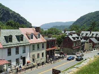
Mile 60.2 - Downtown Harpers Ferry, WV
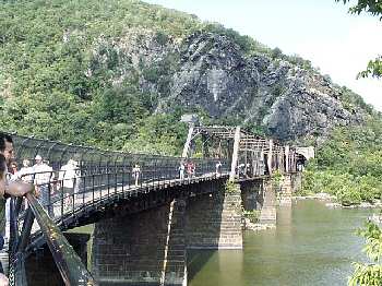
Mile 60.2 - Footbridge to Harpers Ferry and Maryland Heights cliffs
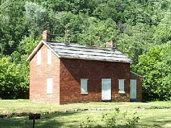
Mile 58 - Lockhouse 33 marks the Appalachian Trail intersection
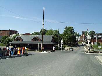
Mile 55 - The rail station at Brunswick, MD
After about 30 miles of "remote" wilderness, things start to get crowded as the canal enters the Appalachian Mountains. In the narrow valleys, river, canal, railroad, and highway must compete for limited real estate. During the early 1800s, the canal and railroad companies were constantly involved in legal battles surrounding these right-of-ways. In some of the tighter sections, you will note that the railroad has since taken over the abandoned canal bed.
Mile 51.5 is the site of the Catoctin Creek Aqueduct. This aqueduct completely collapsed several years ago and has since been replaced by a footbridge. A few miles past, you enter the Brunswick, MD area. This town contains a small railroad yard and an RV campground along the river.
The towpath is typically quite bumpy here, since traffic uses it to access the campground. Route 17/287 also crosses the Potomac here at mile 55. This road runs south to Purcellville, VA (via Lovettsville) where you can catch the western terminus of the W&OD Trail. However, Route 287 is not very cyclist friendly (fast traffic and no shoulder). Instead, I recommend you use one of the very nice country roads to the east or west of Route 287. Look for the State Road 663 intersection, about 1 mile south of the river.
The highlight in this section is the town of Harpers Ferry, located at the fork of the Potomac and Shenandoah Rivers. This town, now a National Historic Park, has a long history of floods and wars. A walkway along one of the railroad bridges provides easy access from the canal. On both trips, I stayed at the Hilltop House, which has a restaurant and a wonderful view of the valley. (only some rooms have TVs, so specify if you would like one). The less expensive alternative is the Comfort Inn.
The ten mile section upstream of Harpers Ferry is one of my favorite sections. This area played a big part in Civil War history. The John Brown abolitionist revolt at the Harpers Ferry Arsenal was credited as one of the major events leading to the Civil War. Several years later, the Union and Confederate armies fought the bloodiest battle of the war at Antietam Creek just outside Sharpsburg, MD.
This section makes a great day trip for the whole family. It is only
about an hour drive from Washington. The towpath here is typically in good
shape. After biking for a few miles, you can march over the river and check
out the historic section of Harpers Ferry. This is also a nice hiking
trail to the top of the Maryland Heights cliffs overlooking the town.
To reach this area from Washington, DC:
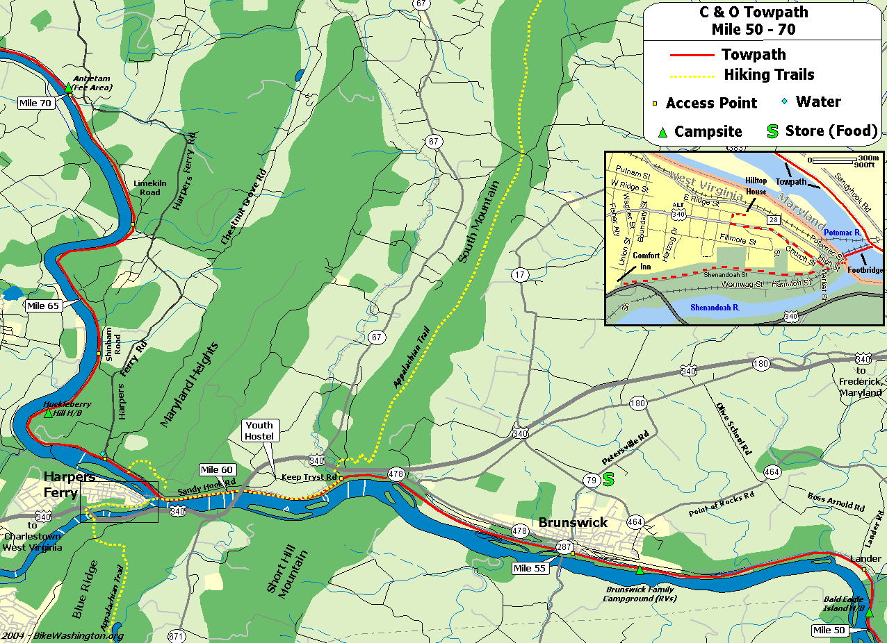
Towpath Map - Mile 50 thru 70
| Mile | Name | Info | |||||
|---|---|---|---|---|---|---|---|
| 49.0 | Lockhouse 28 | Stay in a real lock house. Rustic, no heat, electricity, or running water. Nearest water is 1.4 miles upstream. Close proximity to active railroad, so earplugs are a must for sleeping. | X | ||||
| 50.3 | Bald Eagle Island H/B | Hiker/Biker campsite. 0.5 miles from vehicle access at mile 50.8. Located near a busy railroad line, so earplugs are suggested. | X | X | |||
| 50.9 | Lock 29 | Access from Lander Road | X | ||||
| 51.5 | Catoctin Creek Aqueduct | The number 3 aqueduct is noted for the unusual center arch. It completely collapsed in October 1973. The beautifully restored aqueduct was completed in 2011. | |||||
| 52.5 | Culvert 82 Washout (map) | In May 2018, this culvert was destroyed by flooding. The towpath was impassible at this point until summer 2019 when the park service installed a temporary low-water crossing. | |||||
| 54.0 | Brunswick Family Campground (map) | 301.834.9950: Private Campground - Showers. Located between towpath and river. Appears to be VERY popular with RVs, but expect railroad noise. Cabin and Bicycle Rentals also available. | X | ||||
| 55.0 | Brunswick, MD | Ample parking. A couple of restaurants, but no easily accessible convenience stores. Access to Virginia via route 17/287 | X | ||||
| 55.0 | Brunswick Heritage Museum (map) | 301.834.7100: 1/4 mile from canal in downtown Brunswick (about 1 block past the railroad station). Includes 1700 square foot HO Scale model railroad. Also houses the Brunswick C&O Visitor Center. Open Fri, Sat, and Sun only | |||||
| 55.0 | Georges Mill Farm B&B (map) | 540.822.5224: Lovettsville, VA - about 5 miles south along Route 287. | X | ||||
| 55.0 | Beans in the Belfry (map) | 301.834.7178: Popular internet cafe located 0.3 miles from towpath in old church. Offering coffee, sandwiches, soups, salads, and WiFi. Go past the railroad station and turn left at the light. Just past the top of the hill near the bridge. 122 West Potomac St. | X | ||||
| 55.0 | Brunswick Visitor Center (map) | 301.834.7100: 40 West Potomac Street, with railroad Museum | |||||
| 55.0 | Potomac Street Grill (map) | 301.969.0548: American, Tex-Mex, and Middle Eastern food. 31 E Potomac St. | X | ||||
| 55.0 | King's Pizza (map) | 301.834.9999: Go past the railroad station and turn left at the light. Just past the top of the hill one the other side of the bridge. 215 West Potomac St. | X | ||||
| 55.0 | Three Points Cycle (map) | 301.834.7199: Full Service bicycle shop. Located just 150 yards from the towpath. 5 West Potomac St, Brunswick, MD 21716 | |||||
| 55.0 | Smoketown Brewing Station (map) | 301.834.4828: Enjoy a brew at the town's former former fire station. Feel free to bring your own food or visit any of our town's great restaurants (King's Pizza is right around the corner). 223 Potomac Street. | X | ||||
| 58.0 | River & Trail Outfitters (map) | 888.446.7529 : Bike Rentals and other recreation services | |||||
| 58.0 | Appalachian Trail | The famous 2,181 mile long hiking trail that runs from Maine to Georgia. The trail comes down off South Mountain, and follows the towpath upstream for about 3 miles, leaving at Harpers Ferry. | X | ||||
| 60.2 | Sandy Hook, MD (map) | ||||||
| 60.7 | Harpers Ferry, WV (map) | National Historic Park. Railroad Station, serving Amtrak and MARC (No bicycles on MARC). IMPORTANT: The footbridge to Harpers Ferry was destroyed by a train derailment in Dec 2019. It is closed until further notice. | X | ||||
| 60.7 | Quality Inn (map) | 304.535.6391: 25 Union Street, Harpers Ferry, WV - about 1.5 miles from towpath. From the historic area, follow Shenandoah St to Rt 340, then go right on the wide shoulder for about 100 yards. Hotel will be on the right. This avoids the hill on Washington St. | X | ||||
| 60.7 | River Riders | 800.326.7238: Harpers Ferry, WV - half day bike rentals for $25. Also offers multiday tour packages | |||||
| 60.7 | Harpers Ferry Dining (map) | Numerous restaurant options on the block across from the railroad station. Coffee, delis, pubs, self serve, ice cream. Mostly lunch and dinner options. Online ratings favor Cannonball Deli and Private Quinn's Pub. | X | X | |||
| 60.7 | The Town's Inn (map) | 877.489.2447: This recently renovated inn is the only lodging in Lower Town Harpers Ferry, and closest option to the Towpath. 21 beds in 7 rooms. 179 High Street, Harper's Ferry, WV | X | ||||
| 60.7 | Harpers Ferry Outfitters (map) | 304.535.2087: General Store location (near railroad station) offers bicycle rentals and basic bike parts (such as tubes). Full service hiking equipment on block up the hill. | |||||
| 61.2 | Maryland Heights Hiking Trail (map) | Use footbridge over canal - Hiking trail to top of cliffs overlooking Harpers Ferry | X | ||||
| 61.5 | Harpers Ferry Road Access | Very small parking lot. No parking on weekends (raft access only) | X | X | |||
| 62.9 | Huckleberry Hill H/B | Hiker/Biker campsite. Remote - No nearby vehicle access. | X | X | |||
| 64.9 | Dargan Bend Recreation Area | Large Parking Area (40-50 vehicles) - Access from Back Rd | X | ||||
| 67.4 | Mountain Lock Recreation Area | Parking Area (10-15 vehicles) - Access from Limekiln Rd, just down hill from Harpers Ferry Rd | X | ||||
| 69.3 | Antietam Aqueduct | The forth of 11 stone aqueducts constructed. Crosses Antietam Creek, which flows through the famous battlefield. | |||||
| 69.8 | Antietam Creek Recreation Area | Easy vehicle access - 20 Campsites - Fee Area: $10/Night | X | X | X |