Bike Washington’s
C&O Canal Bicycling Guide
Food & Water
| Trip Planning | Mile-by-Mile | Trip Reports | Info-to-Go |
|
|
Bike Washington’sC&O Canal Bicycling Guide | Food & Water |
|
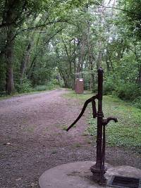
Water Pump at Hiker/Biker Campsite
Where can I find water? Water pumps are located at each Hiker/Biker Campsite, roughly every 5 miles. This water is safe to drink. The pumps are tested weekly by the Park Service. If a problem is found, they will remove the pump handle. The water pumps are also shut down between mid-November and mid-April to prevent freeze damage.
Although safe to drink, the pump water is not always "Perrier quality". You will find that it is typically discolored and may have a funny taste. Some folks will add a sport drink mix to mask the flavor, or bring along a water filter. Also, keep in mind that some of these wells are pretty deep. As a result, it may take quite a few pumps before you actually see any water come out of the pump.
The other option is to load up on water at one of the food stops listed below. These stops are roughly every 15 miles, so if you go this route be sure to carry enough water storage. I used a two litter Camelback, with an additional liter bottle in my pack and a standard bicycle water bottle on my bike frame. This allowed me to carry a full gallon of water, which goes quickly during the hot summer months. The downside is this adds another eight pounds to your load!
Where can I find food? You can carry your own food with you, but money is a heck of a lot lighter! Food stops are located every 15 miles or so. We typically stopped for lunch at a deli or general store. However, we always carried some extra food with us for snack breaks.
If you are camping, then you should plan to bring along some "yummy" dehydrated food packets for breakfast or dinner. On my camping trips, I found that it is most convenient to cook dinners at the campsite. For breakfast, I would just have a powerbar while breaking camp. I would then stop at the next store for a more balanced mid-morning snack.
Here are some suggested food stops:
| Mile | Name | Info |
|---|---|---|
| 0.1 | Washington Harbour (map) | Several outdoor cafes along the waterfront. |
| 3.1 | Fletcher's Cove | 202.244.0461: Snack Bar. Single-speed bike and boat rentals. Nice area for a picnic. Parking available. |
| 8.4 | Cabin John (map) | Cabin John Shopping Center (at MaCarthur and 79th St) located about 0.5 mile away from river (Deli / Store). Cross lock and follow wide path to left. Becomes paved Riverside Ave. Follow thru tunnel and continue 79th St. |
| 14.3 | Great Falls Snack Bar (map) | Hotdogs and burgers. Located in large parking area. |
| 35.7 | White's Ferry Grill | 301.250.3077: Located right off the towpath. The grill management changed in 2019. Currently open 6 days a week - closed Mondays. Check website for latest. |
| 42.1 | Dickerson Market (map) | 301.349.5789: Food and Grocery Market located about 1.5 miles from the towpath in Dickerson. 22145 Dickerson Rd. |
| 48.2 | One Stop Deli and Grocery (map) | 301.874.2691: Small Deli located in Exxon, about 0.7 miles from Towpath (just past the train station). |
| 48.2 | Aroma House (map) | 301.874-8100: Pizza and Gyros, located 0.7 miles from the towpath (just past the train station). 1595 Bowis Dr |
| 48.2 | Roadhouse Jerk (map) | 301.810.5782: Jamaican cuisine just off the towpath in Point-of-Rock, MD. Lunch, and dinner. 3710 Clay St. |
| 55.0 | Beans in the Belfry (map) | 301.834.7178: Popular internet cafe located 0.3 miles from towpath in old church. Offering coffee, sandwiches, soups, salads, and WiFi. Go past the railroad station and turn left at the light. Just past the top of the hill near the bridge. 122 West Potomac St. |
| 55.0 | Potomac Street Grill (map) | 301.969.0548: American, Tex-Mex, and Middle Eastern food. 31 E Potomac St. |
| 55.0 | King's Pizza (map) | 301.834.9999: Go past the railroad station and turn left at the light. Just past the top of the hill one the other side of the bridge. 215 West Potomac St. |
| 55.0 | Smoketown Brewing Station (map) | 301.834.4828: Enjoy a brew at the town's former former fire station. Feel free to bring your own food or visit any of our town's great restaurants (King's Pizza is right around the corner). 223 Potomac Street. |
| 60.7 | Harpers Ferry Dining (map) | Numerous restaurant options on the block across from the railroad station. Coffee, delis, pubs, self serve, ice cream. Mostly lunch and dinner options. Online ratings favor Cannonball Deli and Private Quinn's Pub. |
| 72.8 | Route 34 Bridge | Large Parking Area, about 0.1 mile downriver from bridge. Restaurants located across river in Shepherstown, about 3/4 mile. |
| 72.8 | Shepherdstown Dining (map) | Numerous dining options in this university town, including pizza, Chinese, and Thai. Cross bridge and ride up the hill. Left at 4-Way stop onto W German Street. |
| 72.8 | Blue Moon Cafe (map) | 304.876.1920: Popular pub just one block off the beaten path. Corner of Princess & High Streets. |
| 76.8 | Battleview Market (map) | 301.432.2676: A bit off the trail, but the deli here is a great food option when visiting the Antietam Battlefield. 5331 Sharpsburg Pike. |
| 76.8 | Captain Benders Travern (map) | 301.432.5813: Great food, micro-brew beers, wine and mixed drinks. Easy trek from Snyder's Landing into town. Not far from Antietam Battlefield. 113 East Main Street |
| 84.2 | Downsville General Store (map) | 301.223.6401: Small Deli located in Downsville, MD. About 1 mile off the detour via Dam Number 4 road |
| 99.4 | Tony's New York Pizza (map) | 301.223.6266: Great place to load up on carbs. Corner of Salisbury and Conococheague Streets |
| 99.4 | Desert Rose Cafe (map) | 301.223.6400: Swing by for a cup of soup, a healthy sandwich or salad and perhaps an espresso or smoothy. Recently relocated to a larger space at 42 N Conococheague Street |
| 99.4 | Third Base Tavern (map) | 301.223.8274: Great place to cool off with a beer. 35 N. Conocheague St |
| 124.1 | Park-N-Dine Restaurant (map) | 301.678.5242: 189 E Main St |
| 124.4 | Triangle Tavern (map) | 301.678.6175: Excellent food, well stocked bar. Owner and staff very friendly to the hiker/biker community. 200 E Main Street, Hancock, MD |
| 124.4 | C&O Bicycle (map) | 301.678.6665: Hancock, MD - Full Service Bike Shop, right next to the towpath on Penn Ave. Also offers overnight bunk house and snacks. Open 8am to 6pm daily. |
| 124.4 | Weaver's Restaurant (map) | 301.678.6346: A towpath favorite. Great deserts! 77 W Main St |
| 124.4 | Buddy Lou's (map) | 301.678.6460: Light menu, mainly sandwiches and finger food, micro-brew beers, wine and mixed drinks. Nice deck overlooking the rail-trail. 11 E Main Street |
| 140.8 | Bill's Place (map) | 301.478.2701: This bar is a longtime favorite stop along the towpath. Closed Tuesday and Wednesday |
| 140.8 | Little Orleans Campground (map) | 301.478-2325: Private Campground - RV and tent sites 1/4 mile from the towpath. Showers, pool, camp store. |
| 156.2 | Paw Paw, WV (map) | General Store and Quick Mart. Located about 1 mile from towpath, across the river, via Route 51. |
| 166.7 | The School House Kitchen (map) | 301.478.5189: Restaurant and Community Center located in the old high school. Opposite direction from the toll bridge. Right at the tee, and the kitchen is one block on the right. |
| 173.3 | Spring Gap Recreation Area (map) | Primitive RV and Tent Camping - Fee Area $10/night. Store located on Route 51. |
| 184.5 | Cumberland, MD (map) | Trail heads for both the C&O and GAP trails. Several restaurants nearby; Continue north past the historic railroad station, then turn right at Baltimore St. |
| 184.5 | The Crabby Pig (map) | 301.724.7472: You've just completed 185 miles. Have a beer! Right near the Fairfield Inn. 13 Canal St. |