Bike Washington’s
C&O Canal Bicycling Guide
Starting Point
| Trip Planning | Mile-by-Mile | Trip Reports | Info-to-Go |
|
|
Bike Washington’sC&O Canal Bicycling Guide | Starting Point |
|
From which end should I start? Once you're ready for the trip, you need to decide from which end to start. If you begin in Cumberland, as I did on my 1994 and 2003 trips, then will have a slight downhill advantage. There are 75 locks on the canal, and at each lock the towpath makes a short 6 to 8 foot incline. By starting from Cumberland, you get to go down each of these 75 inclines.
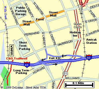
Cumberland, MD Trail Head (Mile 184)
Cumberland is about a 2 ½ hour drive from D.C. You get there by taking I-270 North to I-70 West. Follow I-70 to Hancock, MD where you will pick up I-68. This takes you out to Cumberland. The Cumberland Trail Head is easily accessible from Exit 43C on I-68. Keep in mind that it ends just north of I-68 where the interstate crosses the river. The Western Maryland Scenic Railroad Station is right near the where the towpath terminates.
|
Can't get to Cumberland?
|
There are two problems with beginning in Cumberland. First, it is hard to organize an early start unless you spend the prior night in Cumberland. Secondly, once you get started, it's a MAJOR PAIN getting any help in case you run into problems. During my first trip, my brother became sick after 25 miles. We spent most of the day in Paw-Paw, West Virginia waiting for the "evac" (This is probably the most remote part of the trip). By the time helped arrived, it was too late to contine, so I had to be shuttled to Hancock, MD to be ready for the next day.
Washington, DC Trail Head (Mile 0)
For the 1995 and 2004 trips, I started from the Georgetown section of Washington, DC. For me, this worked out much better because I was able to get an early start and the entire first day is within an hour of "civilization". This did mean an uphill trip, but the inclines are so short and infrequent, it was no big deal.
I would suggest that you actually start off using the Capital Crescent Trail. Follow the CCT for two miles until you reach Fletcher's Boathouse. At this point you can easily hop over to the Towpath. If you really want to start from "Mile 0", then you need to go back toward the Rock Creek Parkway. The trail head starts off as a red brick paved walkway, just south of the Pennsylvania Ave - Rock Creek overpass. However, this first mile is a real pain to bike. The trail is very narrow in spots with a couple of twists and turns, and there are several road crossing.
Note to RVers: There are several RV Campgrounds near Williamsport, which is very near the midpoint of the towpath. You can leave the RV at one of these campground and then make a one or more day round-trip excursion toward Washington or Cumberland.
Note to Scoutmasters:: Planning a troop outing on the towpath? Got Questions?
We got answers. Check out the Scout Info page.
When should I start? Almost any time of year is good (except maybe when there's snow). Don't let the hot summers scare you. The towpath is almost all shaded and the river tends to keep the temperature down about 10 to 15 degrees. However, you should try to get an early start each day, because afternoon thunderstorms are common during the summer, and I can tell you that a muddy towpath is not much fun. In the event of a short storm, the towpath typically dries out enough after a couple of hours. However, if there is a prolonged period of rain prior to your trip, you may want to think about rescheduling.