Bike Washington’s
C&O Canal Bicycling Guide
Mile 40 thru 50
| Trip Planning | Mile-by-Mile | Trip Reports | Info-to-Go |
|
|
Bike Washington’sC&O Canal Bicycling Guide | Mile 40 thru 50 |
|
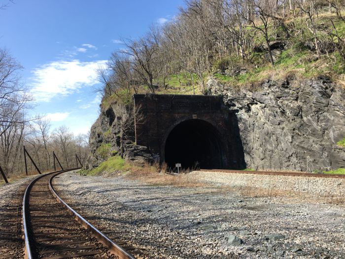
Mile 48.3 - The B&O Tunnel and track encroachment
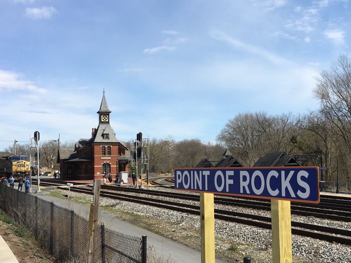
Mile 48.2 - Point-of-Rocks Train Station
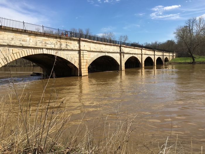
Mile 42.1 - The Monocacy Aqueduct
The only other point of interest that you "might" see in this section is the Dickerson power plant (mile 41). In 1992, a training course was built in the power plant's warm water discharge spillway for the US Olympic Kayak Team. You might be able to see it through the chain-link gate at the south side of the complex.
Trail conditions are historically poor in the mile or two prior to the town of Point-of-Rocks, Maryland. Expect to navigate around many mud holes in this section. The rest of the path is typically in good shape.
Access to the town of Point-of-Rocks is by way of a small, wooden, one-lane bridge over the canal bed. This town is a good lunch/re-supply stop as there is a deli's about a block off the towpath. Also, be sure to roll down to the beautiful Point-of-Rocks railroad station, one of the most photographed stations in Maryland. There is also a small strip mall a bit further past the railroad station that contains a pizza shop and deli.
Just after the wooden bridge, the C&O Canal passes through the Catoctin Mountain Range. During the canal construction, the B&O Railroad mounted an unsuccessful legal challenge for the narrow right-of-way through this pass. As a result, the railroad was forced to tunnel through the mountain. After the canal failed, the railroad built a second track in the abandoned canal bed. However, the towpath is still intact through the pass.
Point-of-Rocks also hosts one of the Potomac River gages. You can check the current river height over at Weather.gov. The flood stage at this location is 16 ft, but the towpath is generally not affected until the river reaches 22 ft. The record at this location was 41 ft during the 1936 flood.
Access Points from westbound Route 28:
Access Points from Route 15:
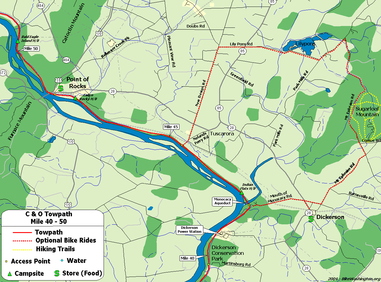
Towpath Map - Mile 40 thru 50
| Mile | Name | Info | |||||
|---|---|---|---|---|---|---|---|
| 39.5 | Dickerson Conservation Park (map) | Access from Martinsburg Rd. | X | ||||
| 41.6 | Dickerson Power Plant | US Olympic Kayak Team trains in spillway next to towpath. | |||||
| 42.1 | Monocacy Aqueduct | This impressive structure is the largest aqueduct on the towpath. Originally completed in 1833, was restored in 2005. | X | ||||
| 42.1 | Dickerson Market (map) | 301.349.5789: Food and Grocery Market located about 1.5 miles from the towpath in Dickerson. 22145 Dickerson Rd. | X | ||||
| 42.4 | Indian Flats H/B | Hiker/Biker campsite. 0.3 miles from vehicle access at mile 42.1 | X | X | |||
| 44.6 | Nolands Ferry | Boat Ramp and Picnic Area. Access from New Design Road. | X | ||||
| 47.6 | Calico Rocks H/B | Hiker/Biker campsite. 0.8 miles from vehicle access at mile 48.2. Located near a busy railroad line, so earplugs are suggested. | X | X | |||
| 48.2 | Point of Rocks, MD | This town marks the location where the Potomac river cuts through the Catoctin Mountain ridge. The Route 15 Bridge provides alternate bike access to Virginia (when Whites Ferry is closed). Note that Route 15 is very hazardous and NOT recommended for bicycle access to Leesburg. Use state route 665 instead. | X | ||||
| 48.2 | One Stop Deli and Grocery (map) | 301.874.2691: Small Deli located in Exxon, about 0.7 miles from Towpath (just past the train station). | X | ||||
| 48.2 | Aroma House (map) | 301.874-8100: Pizza and Gyros, located 0.7 miles from the towpath (just past the train station). 1595 Bowis Dr | X | ||||
| 48.2 | Roadhouse Jerk (map) | 301.810.5782: Jamaican cuisine just off the towpath in Point-of-Rock, MD. Lunch, and dinner. 3710 Clay St. | X | ||||
| 49.0 | Lockhouse 28 | Stay in a real lock house. Rustic, no heat, electricity, or running water. Nearest water is 1.4 miles upstream. Close proximity to active railroad, so earplugs are a must for sleeping. | X | ||||
| 50.3 | Bald Eagle Island H/B | Hiker/Biker campsite. 0.5 miles from vehicle access at mile 50.8. Located near a busy railroad line, so earplugs are suggested. | X | X | |||
| 50.9 | Lock 29 | Access from Lander Road | X |