Bike Washington’s
C&O Canal Bicycling Guide
Mile 130 thru 150
| Trip Planning | Mile-by-Mile | Trip Reports | Info-to-Go |
|
|
Bike Washington’sC&O Canal Bicycling Guide | Mile 130 thru 150 |
|
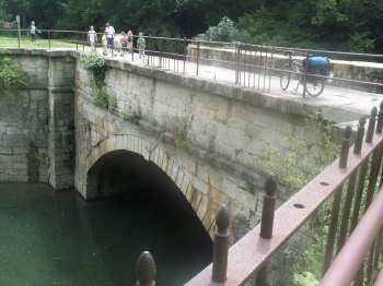
Mile 140.9 - The Fifteen Mile Creek Aqueduct
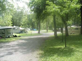
Mile 140.8 - The drive in campground at Little Orleans
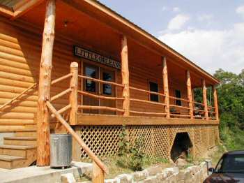
Mile 140.8 - Bill's Place in Little Orleans, MD
This beautiful section is probably the most geographically remote along the entire canal. The rugged mountain terrain provides wonderful scenic vistas, but really limits access points. The only "town" in this section is Little Orleans, which is basically just four or five buildings. The Western Maryland Rail-Trail now extends through Little Orleans, so that provides a nice alternative to the unpaved towpath surface.
The main hangout spot in Little Orleans is Bill's Place, a combination general store and pub. Be sure to drop in and perhaps pin a dollar bill to the ceiling. There are many Hiker/Biker campsites in this section. Fifteen Mile Creek Recreation Area (at Little Orleans) also provides drive in campsites.
This section always seems to be much more "buggier" than the rest of the canal, so make sure you have lots of repellent!
Note: This area is about a 1-¾ hour drive from the Washington Beltway.
Access Points: From Maryland I-68
Mile 130.0: Cohill, MD
Towpath Map - Mile 130 thru 150
| Mile | Name | Info | |||||
|---|---|---|---|---|---|---|---|
| 129.8 | Leopards Mill H/B (map) | Hiker/Biker campsite. 0.9 miles from vehicle access at mile 130.7 | X | X | |||
| 130.0 | Happy Hills Campground (map) | 301.678.7760: Private Campground - Full Service RV and Tent Camping (200 Sites). Cabins and Horse Stables available. 12617 Seavolt Rd | X | ||||
| 130.7 | Cohill, MD | Access from Route 144 via Willow Road | X | ||||
| 133.6 | Cacapon Junction H/B (map) | Remote Hiker/Biker campsite - No vehicle access. | X | X | |||
| 136.3 | Western Maryland Rail Trail (map) | Western trailhead at Lock 56 in Pearre, MD. This paved trail runs parallel to towpath for next 21 miles | |||||
| 136.6 | Sideling Hill Creek Aqueduct | ||||||
| 139.2 | Indigo Neck H/B (map) | Hiker/Biker campsite. 1.6 miles from vehicle access at mile 140.8 | X | X | |||
| 140.8 | Town Hill Hotel B&B (map) | 877.696.2794: Located on top of Town Hill Mt providing beautiful vistas. About 8 miles from Little Orleans. A shuttle service is available, with multiple pickup points. But for extra credit, bike the 1,300 foot climb yourself! | X | ||||
| 140.8 | Bill's Place (map) | 301.478.2701: This bar is a longtime favorite stop along the towpath. Closed Tuesday and Wednesday | X | ||||
| 140.8 | Fifteen Mile Creek Recreation Area (map) | Fee Area: $10 to $20. A Drive-in site with RV and tent sites (Primitive Facilities - No RV Hookups). Free parking available alongside railroad embankment. | X | X | X | ||
| 140.8 | Little Orleans Campground (map) | 301.478-2325: Private Campground - RV and tent sites 1/4 mile from the towpath. Showers, pool, camp store. | X | X | |||
| 140.9 | Fifteen Mile Creek Aqueduct | ||||||
| 144.0 | Long Pond Trail | 7 mile hiking trail to Green Ridge State Forest Visitor Center | |||||
| 144.5 | Devil's Alley H/B (map) | Remote Hiker/Biker campsite. No vehicle access. | X | X | |||
| 149.4 | Stickpile Hill H/B (map) | Remote Hiker/Biker campsite. Rough access point 0.6 miles away at Mile 150 | X | X | |||
| 150.0 | Bonds Landing | Rustic access point from Kasecamp Road. Four wheel drive may be required. | X |